Locations affected: Grenada, Barbados, St Vincent and Grenadines, Jamaica, Mexico
What:
Widespread destruction was reported in various countries in the Caribbean due to Hurricane Beryl, which reached tropical storm status on 28th June and transformed into a major hurricane on 30th June. The storm resulted in large-scale infrastructural damage, landslides, and the deaths of at least six people. The islands of Carriacou and Petite Martinique in Grenada, and Union Island in St. Vincent and the Grenadines, have been reported as the worst affected areas. Another hurricane, Chris, made landfall in Mexico on 30th June, leading to heavy rainfall.
Why:
High ocean temperatures caused the storm to rapidly strengthen by at least 35 miles per hour (mph) within 24 hours after 28th June.
So What:
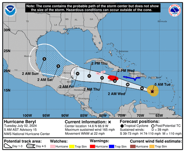
- Hurricane Beryl reached Category 5 strength on 2nd July with wind speeds of 165 mph. It was later downgraded to a Category 4. A Category 5 hurricane has wind speeds of more than 157 mph, while a Category 4 hurricane has wind speeds between 130-156 mph.
- Hurricane Beryl made landfall on Carriacou Island. Power outages were reported across Grenada and St. Lucia. Widespread damage to homes and buildings was seen in St. Vincent and the Grenadines, St. Lucia, and Venezuela.
- Flight operations were affected across multiple countries impacted by the storm. Sangster International Airport and Norman Manley International Airport in Jamaica were closed on 2nd July.
- The government of Jamaica has issued a hurricane warning as Beryl is forecasted to affect the island on 3rd July. It is predicted to produce rainfall of 4 to 8 inches and could trigger flash flooding in vulnerable areas.
- Tropical storm warnings were issued in areas such as Cabo Rojo and Puerto Veracruz due to the anticipated effects of Hurricane Chris.
Outlook:
Hurricane Beryl is likely to be an active storm for several days. The hurricane is expected to cause rainfall and flooding in Barbados, St. Vincent and the Grenadines, and the Windward Islands, with up to 10 inches of rain in isolated locations. It is expected to weaken to a Category 1 hurricane (wind speeds of 74-95 mph) and affect Yucatan, Mexico, by the 4th or 5th of July. Some forecasting models suggest that Hurricane Beryl could turn northward and affect Texas, United States. The storm will also likely impact Puerto Rico, Haiti, the Dominican Republic, and Cuba. Meanwhile, Hurricane Chris has changed into tropical rainfall and is expected to continue causing heavy downpours and flooding over eastern Mexico.
According to forecasters, the Atlantic hurricane season of 2024 is expected to be more active than usual. In May, the National Oceanic and Atmospheric Administration predicted 17 to 25 storms in 2024, higher than the average of 14 storms during the hurricane season. The rapid transformation of Hurricane Beryl from a tropical depression to a major hurricane in less than 48 hours has increased concern among meteorologists regarding a hyperactive season for major storms. Heavy rainfall, flooding, landslides, and high winds can be expected as the storm moves through the Caribbean. Disruptions in essential services can occur due to potential damage to utility lines. Travel disruptions are likely to continue, including delays and cancellations of flights. Organizations are advised to remain abreast of the situation and prepare necessary contingency plans. The updates regarding the hurricanes can be found on the website by the National Oceanic and Atmospheric Administration (https://www.nhc.noaa.gov/gtwo.php?basin=atlc&fdays=2)


