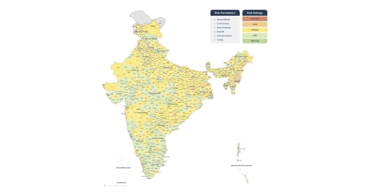
Risk in India is not evenly distributed, and a national average hides that. The India Risk Map 2026 — published by Datasurfr and powered by MitKat Advisory — rates every district in the country against six risk parameters on a single sheet, so planning can happen at the level operations actually run.
What is the India Risk Map 2026?
A district-level risk map covering all of India from a security and safety perspective. Each district is colour-coded against six parameters: geopolitical, civil unrest, environment, health, infrastructure and crime.
How are districts rated?
Five levels, from very low through low, medium and high to very high. Ratings blend likelihood with business impact, so they can differ from the national picture and from one sector to another. Pakistan-occupied Kashmir and Aksai Chin are shown unrated, with the Line of Control and Line of Actual Control marked.
Where is risk highest?
Four clusters stand out. The Kashmir Valley carries high ratings across Kupwara, Baramulla, Srinagar, Pulwama, Anantnag and the Poonch–Rajouri belt. In the Northeast, most of Manipur and several Nagaland districts rate high, with pockets in upper Assam and Arunachal’s Tirap–Changlang belt. Punjab’s border districts, including Tarn Taran, Firozpur and Gurdaspur, form a third. Bastar in Chhattisgarh is the clearest single high-rated district in central India.
What pattern does the map reveal?
Two, and both are useful. Risk tracks borders: the Kashmir, Punjab and Northeast concentrations all sit on or near international frontiers. It also tracks urbanisation — Mumbai, Pune, Hyderabad, Bengaluru Urban and Chennai rate above the largely low-rated districts around them. The rural interior of the south and west is the calmest part of the map.
How should businesses use it?
Match your site list against the map rather than working from a national risk view. Sites in high-rated districts warrant standing security measures, medium-rated urban districts need event and crowd planning, and low-rated districts can run lighter.
Frequently asked questions
What is the India Risk Map 2026?
A single-sheet district-level risk map of India from Datasurfr, powered by MitKat Advisory, rating every district on geopolitical, civil unrest, environment, health, infrastructure and crime risk across five levels.
Which Indian districts carry the highest risk in 2026?
The Kashmir Valley, most of Manipur, several Nagaland districts, Punjab’s border belt and Bastar in Chhattisgarh carry the map’s highest ratings.
Are the 2026 district boundaries up to date?
Mostly. Several state governments declared new districts carved out of existing ones during 2025, but these are not reflected because updated official state maps were unavailable.
Download the full report now
What is inside
- The India Risk Map 2026 rates every Indian district on six parameters: geopolitical, civil unrest, environment, health, infrastructure and crime.
- High ratings concentrate in the Kashmir Valley, Manipur and Nagaland, the Punjab border belt, and Bastar in Chhattisgarh.
- Most of the country sits at medium or low, with risk clustering around cities and borders rather than the rural interior.
- Several districts created during 2025 are not yet reflected, so recently carved districts need checking separately.
Filed under: APACIndia-South AsiaRegional Risk Reviews