Locations Affected: Japan
On 15 July, Typhoon Nari made landfall near Cape Erimo, at the southern tip of Hokkaido. The typhoon had formed over the weekend approximately 200 kilometres south of Chichijima Island in the Pacific and moved along the eastern side of the Japanese archipelago before approaching Hokkaido. This was the first recorded landfall by a typhoon in Hokkaido in July since 1951 and the fifth typhoon to affect Japan in 2025. The Japan Meteorological Agency (JMA) has warned of strong winds and high waves in northern Japan. As of 16 July, no deaths or major injuries have been reported.
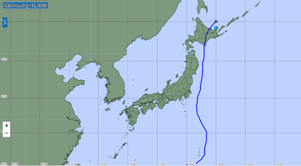
Source: https://www.jma.go.jp/bosai/map.html#5/37.141/141.724/&typhoon=TC2507&contents=typhoon
Climate Change and It’s Effect on Typhoons
According to the JMA, the atmospheric environment in East Japan has become unstable due to various factors, including low pressure over the Sea of Japan and warm, humid air currents. Clouds and rainfall bands formed in the south are moving towards the country. While typhoons typically affect Japan between August and September, warmer seas due to climate change have led to earlier and more intense storms.
Impact of the Typhoon
- On 14 July, the weather agency urged vigilance against strong winds, high waves, and landslides as the typhoon moved northward along Japan’s eastern coast near Tokyo and the northeastern region of Tohoku. Authorities also warned of rapidly rising river levels and the risk of lightning strikes.
- Heavy rainfall was recorded on 14 July in Kochi and Kumamoto prefectures, with Ino Town recording 52 mm of rain and Tamana City recording 32 mm. Rainfall is forecast through 15 July and is expected to reach 200 mm in the Kanto-Koshin region, 80 mm in Tohoku, and 120 mm in Hokkaido.
- Wind gusts in coastal areas prompted warnings of shipping and transport disruptions. Strong winds are expected to continue through 15 July in Hokkaido, with a maximum instantaneous wind speed of 24.3 meters per second observed in Kushiro City.
- The storm passed east of the Tokyo metropolitan area, causing rain and strong gusts that affected train schedules and ferry services.
Weather Forecast and Possible Disruptions
By 0900 hours local time on 15 July, the storm had moved into the Sea of Okhotsk and weakened to become extratropical. However, officials have warned that high winds, rough seas, and heavy rainfall will persist in eastern and northern Japan through 15 July and possibly into 16 July. Continued rainfall could cause inundation in low-lying areas and increase the risk of landslides. Damage to utility infrastructure could lead to disruptions in power and communication services. Travel disruptions are likely to persist depending on weather conditions. Organizations are advised to monitor weather updates and prepare appropriate contingency plans.