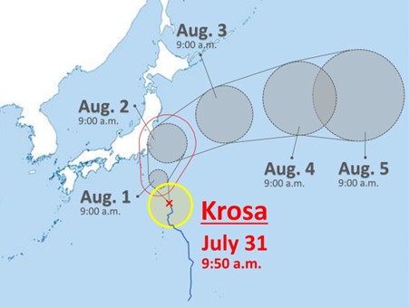
On 31 July, the Japan Meteorological Agency announced that Typhoon Krosa, also known as Typhoon No. 09, had begun slowly moving north-northwest in the Pacific Ocean south of Japan. The typhoon is expected to reach 180 km east-southeast of Hachijojima Island at 0900 hours on 01 August. At the time of the announcement, the central pressure of the storm was 980 hectopascals and the top speed near the centre was 90 kph. Typhoon season in Japan usually occurs between May and October.
Source: https://japannews.yomiuri.co.jp/wp-content/uploads/2025/07/20250731_typhoon_krosa_trim.jpg
Potential Impact of the Typhoon
- As the typhoon moves northward, it is expected to approach the Izu Islands between 01 and 02 August. On 01 August, wave heights are expected to be six meters in the Kanto region and seven meters in the Izu Islands. Maximum wind speeds are expected to reach 23 meters in Kanto and 27 meters in the Izu Islands.
- Authorities have urged residents in Kanto and the Izu Islands to remain vigilant against high waves, storms, swells, landslides, and flooding of low-lying areas.
- Heavy rainfall in Kanto and Izu Islands is also likely due to the storm on 01 and 02 August, with an expected rain of 150mm in the Kanto region and 200mm in the Izu Islands.
- Authorities have also warned that the storm area may disrupt the traffic on the Boso peninsula and nearby areas and have urged travellers to take appropriate precautions.
Outlook on the Situation
The typhoon is likely to cause disruptions in the Kanto region, the Izu Islands, and surrounding areas due to heavy rainfall, high waves, and potential flooding. Damage to utility infrastructure can cause power and communication disruptions in the affected areas. Flooding and high winds could cause travel disruptions, including flight delays and cancellations. Organizations are advised to remain monitor weather updates and warnings and implement necessary contingency plans.

